![]()
Town: North Stonington, Griswold, Preston
Maintained Uses: walking, hiking
Difficulty: moderate
Length: 9.4 miles (blue, yellow, and red trailhead/markers)
Type: network
Surface: packed earth/dirt, pine needles, occasional exposed rocks and roots
Pets: permitted (dogs on leash)
Year Preserved: 2018
Acres: 548.61
Lat.: 41°26’25.4″N
Long.: 71°52’02.1″W
Trail Description
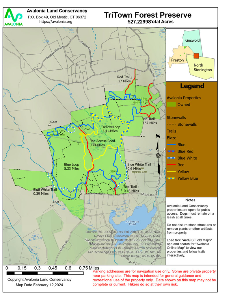
Tri-town Ridgeline Forest Preserve is named due to its location, with trails crossing between the towns of North Stonington, Griswold, and Preston. It is recommended to utilize the largest parking area which is located to the southwest of the preserve, on the north side of Miller Rd in North Stonington. This trail entrance allows for a short 0.2 mile hike to a central intersection of the preserve’s various trails. The outer blue loop is the longest and most challenging of the hikes. Of note, the blue loop features challenging terrain changes with occasional switchbacks, multiple stream crossings, stonewalls of various ages, glacial erratics, stunning vistas, and various side trails that reconnect to the blue loop. The blue loop trail has a trail width that ranges from as narrow as 2 feet to wide open, is packed earth and dirt, and has challenging areas of exposed rocks and roots. In total, the blue loop is approximately 5.2 miles with total elevation changes of close to 1,000 feet. In addition to the blue loop is a yellow loop trail. The yellow loop trail does overlap at times with the blue loop; however, it is easier in difficulty with only 308 feet of elevation changes, has a shorter distance of approximately 2.4 miles, features wider trails, and has less exposed rocks and roots. The red-marked trails serve as access trails and as connectors to the blue and yellow trails. The longest of the red trails is the red connector trail that dissects the preserve, running north to south. This allows for connections to various portions of the blue and yellow loop trails, totaling approximately 0.7 miles. The Linnea Richardson portion of the preserve is the northernmost entry point to the preserve and is one of the red access trails in the town of Griswold. Although parking is not easily appreciated, entering the preserve through this location allows for a welcomed and immediate uphill challenge. After 0.27 miles, this red trail connects to the northern tip of the blue loop trail. Not far and slightly southeast of this access trail is an additional red access trail in the town of Griswold, the Aurelie and Stanley Boyd Tract. Featuring its own split in two different directions and a total distance of approximately 0.65 miles, this access trail allows for an uphill challenge that leads to two different points along the blue loop trail. In total, the red-trailed portions of the preserve are approximately 1.8 miles in length, feature elevation changes of over 500 feet, and range from as narrow as 2 feet to wide open. This gives Tri-town Ridgeline Forest Preserve a total trail distance of approximately 9.4 miles. All trails are easily appreciated and well-marked with colored, hard plastic rectangle trail markers or colored, diamond-shaped trail markers with arrows. Board and bog walks allow for easy traversing of the various wetland areas of the preserve. In addition, there are 5 benches that are strategically placed throughout the preserve. These benches allow for serene views and tranquil resting areas. This preserve is sure to excite with the various nesting birds, loud frogs, deer, and other small land animals. Anticipate seeing other hikers on your adventure, even though it is a large preserve. Pets are permitted (dogs on leash).
More Info
The Tri-town Ridgeline Forest Preserve borders 76 acres of Avalonia-owned open space in Griswold and abuts over 800 acres of conservation easements held by The Nature Conservancy. A 213-acre section of the Pachaug Forest owned by Connecticut DEEP is across the street from Tri-town, and the 24,000-acre Pachaug Forest connects to Rhode Island’s Nature Conservancy Borderlands Project. The Forest protects the headwaters of Miller Brook and Broad Brook (the latter stocked regularly by CT DEEP with brook trout and brown trout) which flow into the Quinebaug River, the Shetucket River, and onto the Thames River, forming part of the Thames River Basin of The Last Green Valley, a National Heritage Corridor.
Ridgeline North Stonington tract – 301.55 acres
Ridgeline Preston tract – 35.15 acres
Ridgeline Griswold tract – 74.50 acres
Peltier’s Lost Pond Preserve tract – 45.58 acres
Boyd Family tract – 54.23 acres
Linnea Richardson Preserve tract – 20.54 acres
![]()
Parade of Life in the Preserve

continue to photo gallery
(images by TriTown Forest Preserve Photo Team)
Trail Map