Avery Preserve
Avery Preserve

Town: Ledyard
Maintained Uses: walking, hiking
Difficulty: moderate
Length: 2.56 miles of total trails (orange, white, and yellow trail/markers)
Type: network
Surface: packed earth/dirt
Pets: permitted (dogs on leash)
Year Preserved: various
Acres: 100.09
Lat.: 41°27’15.0″N
Long.: 72°02’48.0″W
Trail Description – West Tract
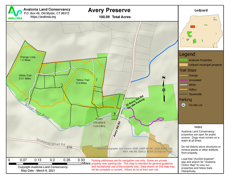
Although Avery Preserve encompasses an East Tract and a West Tract only the West Tract has a trail network. A dedicated parking area is located on the east side of Avery Hill Road. Cross Avery Hill Road to reach the trailhead for the orange trail, which follows the outer boundaries of the preserve. From the orange trail, side trails cross the central portion of the preserve. These trails are marked with either yellow or white trail markers. These connections allow for diverse routes while exploring all of the natural beauty of the preserve. The packed earth and dirt trails range from as narrow as 2-3 feet to wide open, with some stream crossings and vernal ponds along the way. Total trail distance is about 2.5 miles with 270 feet of elevation changes. Combining the hills with the occasional exposed rocks and roots creates a moderately challenging hike. Billings Avery Brook forms the southern boundary of the preserve.
More Info
- Both sides of Avery Hill Road, 0.75 miles north of Route 214. Parking lot on East tract. Approximately 2.5 miles of hiking trails.
- West Tract, 76.59 acres (1970). Open upland deciduous forest, Billings-Avery Brook and glacial boulder deposits. The woods support a number of mature-forest bird species such as hairy and pileated woodpeckers, wood thrushes, ovenbirds and scarlet tanagers.
- East Tract, 22.48 acres (1977). Maple swamp and upland woodlands, rosebay rhododendron, Atlantic white cedar, and orchid species.
- Sheep Wash Tract, 0.49 acres (1995). Historic dry-wall sheep wash, south of Billings-Avery Brook on a side trail near the main entrance to the orange trail.
- Town of Ledyard Transfer, 0.53 acres (2014). Addition to the west tract.
Read More


