Leo Antonino Preserve
Leo Antonino Preserve
Town: Groton
Maintained Uses: walking, hiking. Biking on BLUE-blazed trails only.
Difficulty: blue- and red-blazed trails are easy. Yellow Loop is moderate.
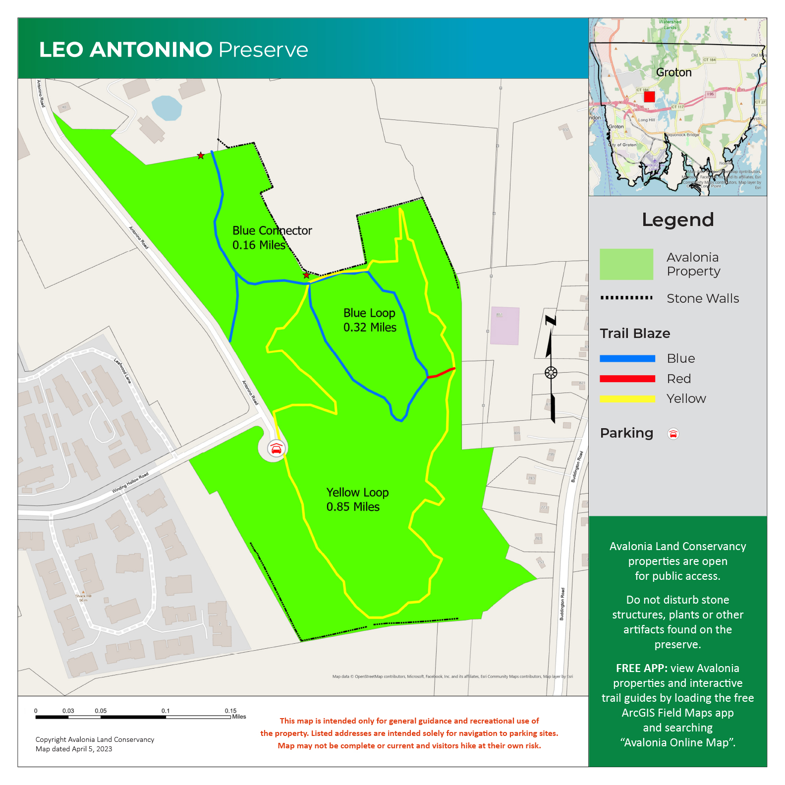
Length: Blue Loop: 0.32 mile. Blue Connector plus spur: 0.2 mile. Yellow Loop: 0.85 mile.
Type: network with interconnecting loops.
Surface: blue, red: wide packed earth. Yellow: some packed earth. Most is single width trail, rocky and rooty, with elevation changes.
Pets: dogs on leash.
Year Preserved: 2018
Acres: 41.48
Lat.: N 41 ̊ 36.733’
Long.: W 72 ̊ 05.026’
Trail Description
Leo Antonino Preserve is an unexpected tract of woods, wetland, rock outcroppings and erratics tucked behind the Gold Star Office Park on Route 184. Parking and the Preserve entry are at the cul de sac at the southern end of Antonino Road which intersects with the Gold Star Highway (Route 184) just east of Girard Nissan (at 425 Gold Star Highway). The Preserve has two primary trails and a short connector that are well marked with yellow, blue and red blazes and with “You Are Here” maps at trail intersections. The primary trailhead is at the parking area at the end of Antonino Road where there is a kiosk with a large-scale map of the preserve, a brief history of the preserve and a summary of its features. Additional trailheads are at the southeastern-most corner of the parking for the Gold Star Office Park (495 Gold Star The Hwy, Groton, CT) and off of Antonino Road across from the intersection with Winding Hollow Road. The Yellow Loop or “Nature Trail” is about 0.85 mile in length.
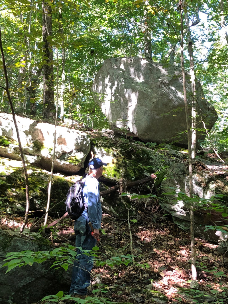
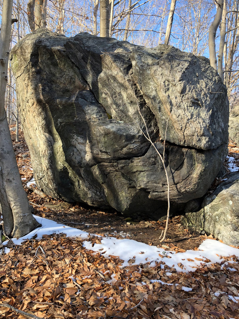
The trail includes short sections of wide-open travel on packed earth and longer stretches of single-file trail that are rocky and rooty with elevation changes. The trail travels through areas of beech and oak and along vernal pools and active brooks. Erratics and upthrust sections of granite illustrate the geologic history of this section of Connecticut. Also illustrative of the history of this property, the yellow trail features the wreck of an old Chevy truck. The section of the yellow trail north of the Chevy is the most challenging with a scramble over a steep rocky ridge. The Blue Loop is about 0.3 mile around and is contained within the Yellow Loop, overlapping with it along its northern stretch. The Blue Loop is a wide, packed earth, Jeep or truck track from bygone days. There is one steep hill, but it is a fairly easy trail. There is a short connector between the Blue and Yellow Loops at the southeastern corner of the Blue Loop. It is blazed in red and allows hikers to avoid the hardest part of the Yellow Loop. A Blue Connector links the Blue and Yellow Loops to the office park, and a short blue blazed spur off the Connector leads to Antonino Rd. Bicycling is allowed on the BLUE-blazed trails ONLY, and you may see folks commuting from the Winding Hollow neighborhood to the Office Park on a bike.
More Info
While it lies in a commercial area, the preserve is a valuable connector between privately and publicly owned open space and drains into the Groton Reservoir. At one point, it was slated to be flattened and become commercial space and parking. In part because of its environmental and watershed value, the Groton Planning Commission and other Town offices as well as private citizens opposed this plan that finally was withdrawn.