![]()
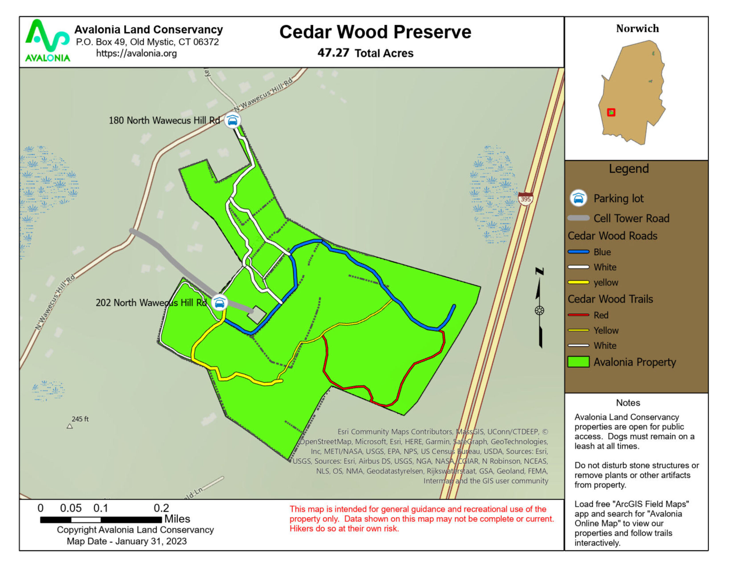
Town: Norwich
Maintained Uses: walking, hiking, birding, biking, photography
Difficulty: easy to moderate
Length: ~1.7 miles of total trails (3 Loop Trails)
Type: interconnected loop network
Surface: Fully Accessible Handicapped parking; grass/meadow and packed earth/dirt
Pets: permitted (dogs on leash)
Year Preserved: 2021
Acres: 47.27
Lat.: 41°31’45″
Long.: 72°07’25″
Property entrance is located at 180 North Wawecus Hill Road in Norwich just about across from Tillies Way. The preserve is adjacent to an open field.
Trail Description
Cedar Wood Preserve features a relatively flat upper section near the entrance and open woodlands as you go further into the property. The property was farmed until about 2017. The open farm fields in the upper section have mown paths but are not marked. Many of the mown paths are shown as white trails on the map but are subject to change periodically. The fields are allowed to grow during the summer but are mowed in the spring or fall to keep down invasive plants many of which became established after farming stopped.
Starting at the entrance at 180 North Wawecus Hill Road you will quickly come to an elevated walkway over a vernal pool. Proceeding SSE along the mown paths you will pass through open fields with native flowers and grasses. Bird nesting boxes have been installed here. Note the high Chimney Swift nesting tower to help out this species of concern.
Coming to a dirt road servicing the cell tower, you will jog to the left to the start of the yellow trail. This trail begins as a tractor road before turning into a narrow hiking trail later.
A short way along the yellow road you will come to the start of the blue road trail which goes behind the cell tower to several paths that will take you back to the entrance.
If you go to the furthest white trail, the loop is 0.42 miles in length. This is an easy, level hike and is being studied as a potential accessible trail.
If you choose to follow the yellow trail, you begin to descend until you are in an open woodland.
Just before the blue trail, you will pass over a bridge crossing an intermittent stream.
Turn left on the blue trail and climb up to the white trail to the entrance. This loop is 1 mile long. Hiking difficulty for this trail is easy to moderate with a bit of a climb to get back up the blue road.
If you choose to turn right off the yellow trail following the red trail, your total loop is 1.43 miles long. The red trail is steeper in spots and rockier than the others. The difficulty is moderate. Near our property line, the trail crosses a narrow rock dam that may challenge some hikers. A future bridge is planned here at the low point of the preserve. The elevation change from this dam to the high point near the entrance is 100 feet.
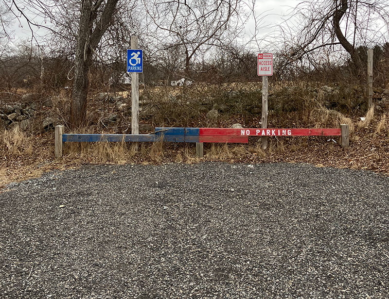
Cedar Wood Preserve Accessible Parking for People with Disabilities
You will notice that the accessible space at Cedar Wood looks very different from the more typical accessible spaces found throughout Connecticut. Those spaces, required by (and conforming to) the Connecticut State Building Code, all serve nearby structures and are strictly limited to permit holders. When a parking area does not serve a structure (as at Cedar Wood and most land preserves), the Code does not apply; in that case, an entity must defer to the parking standards of the Americans with Disabilities Act (ADA).
This accessible parking space, based on an innovative model created by the Massachusetts Department of Conservation and Recreation, meets the intention of the ADA without compromising the environmental principles that would be violated by paving. The primary innovation of the space is the use of blue and red guiding ‘bumpers’ that indicate the components of the space normally communicated by striping. The space is intended for accessible parking permit holders, but (per an ADA exception for lots having four or fewer total spaces*) those without permits may park there when no other space is available. (No vehicle, however, may be parked in the access aisle.)
* ADA Standards 216.5
For a more complete explanation of the ADA and Building Code contexts, please contact the Avalonia office at avalonialc@yahoo.com or 860-884-3500.
Trail Map